


LIBERTY TWP LIBERTY22 Voting District, Butler County, Ohio
About
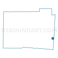
Outline

Summary
| Unique Area Identifier | 643020 |
| Name | LIBERTY TWP LIBERTY22 Voting District |
| County | Butler County |
| State | Ohio |
| Area (square miles) | 1.15 |
| Land Area (square miles) | 1.15 |
| Water Area (square miles) | 0.00 |
| % of Land Area | 100.00 |
| % of Water Area | 0.00 |
| Latitude of the Internal Point | 39.37535400 |
| Longtitude of the Internal Point | -84.35521120 |
Maps

Graphs
Select a template below for downloading or customizing gragh for LIBERTY TWP LIBERTY22 Voting District, Butler County, Ohio


Neighbors
Neighoring Voting District (by Name) Neighboring Voting District on the Map
- 0142 MAS-C-WB Voting District, Warren County, OH
- 0160 DEF-T-NA Voting District, Warren County, OH
- 0171 DEF-T-NB Voting District, Warren County, OH
- LIBERTY TWP LIBERTY14 Voting District, Butler County, OH
- LIBERTY TWP LIBERTY23 Voting District, Butler County, OH
- LIBERTY TWP LIBERTY4 Voting District, Butler County, OH
- WEST CHESTER TWP WC41 Voting District, Butler County, OH
Top 10 Neighboring County Subdivision (by Population) Neighboring County Subdivision on the Map
- West Chester township, Butler County, OH (60,958)
- Liberty township, Butler County, OH (37,259)
- Deerfield township, Warren County, OH (36,059)
- Mason city, Warren County, OH (30,712)
Top 10 Neighboring Place (by Population) Neighboring Place on the Map
Top 10 Neighboring Unified School District (by Population) Neighboring Unified School District on the Map
Top 10 Neighboring State Legislative District Lower Chamber (by Population) Neighboring State Legislative District Lower Chamber on the Map
Top 10 Neighboring State Legislative District Upper Chamber (by Population) Neighboring State Legislative District Upper Chamber on the Map
Top 10 Neighboring 111th Congressional District (by Population) Neighboring 111th Congressional District on the Map
Top 10 Neighboring Census Tract (by Population) Neighboring Census Tract on the Map
- Census Tract 319.03, Warren County, OH (16,114)
- Census Tract 111.20, Butler County, OH (7,393)
- Census Tract 111.09, Butler County, OH (4,389)
- Census Tract 111.25, Butler County, OH (3,623)
- Census Tract 111.18, Butler County, OH (3,014)